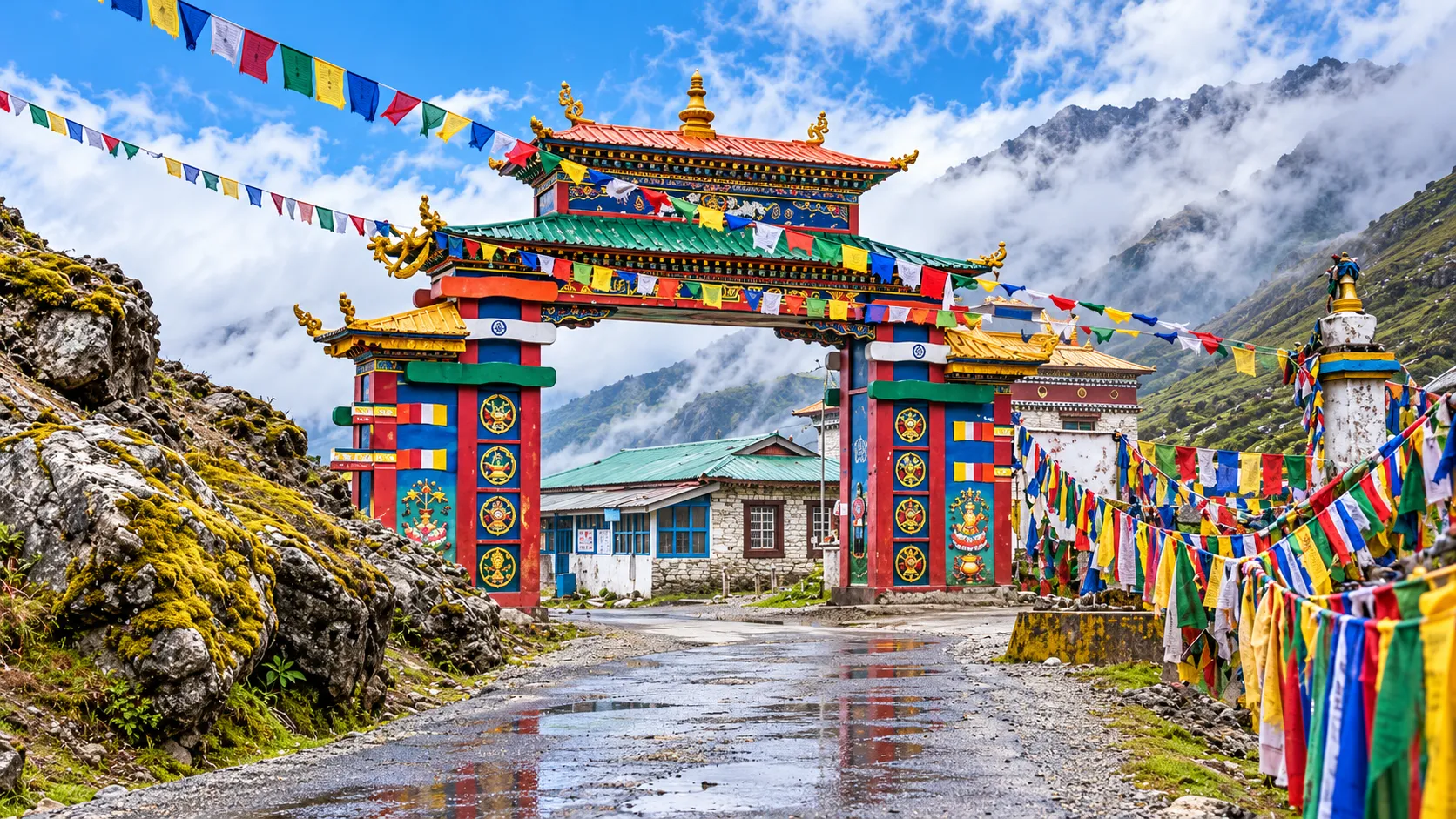
Bomdila is a hill town in the West Kameng district of Arunachal Pradesh, spread along a ridge at roughly 2,400 metres. Most travellers meet it as a night stop on the road from Assam to Tawang, and that is a fair description of its place in the journey. It is also a town worth a little more time than that. Three Buddhist monasteries sit within a short distance of each other, orchards climb the slopes around it, and on clear days the ridges fall away toward the Himalaya.
For anyone heading to western Arunachal, Bomdila does practical work as well. It is the first town at real altitude after the climb from the plains, which makes it a sensible place to let your body adjust before Dirang, Sela Pass and Tawang. This guide covers where it sits, what to see, when to go, how to get there and how to build it into a longer trip. Weather, roads, permits and opening arrangements change, so we mark what to check locally before you travel.
Where is Bomdila?
Bomdila is the headquarters of West Kameng district, in the western part of Arunachal Pradesh. It lies on the highway that climbs from the Assam border at Bhalukpong toward Dirang, Sela Pass and Tawang, so almost every road trip through this part of the state passes through it.
Distances vary a little between sources, but the rough picture is consistent. Bhalukpong, the entry point from Assam, is around 110 km below, a drive of several hours on winding road. Tezpur is roughly 155 km away, Dirang about 42 km further along toward Tawang, and Tawang itself roughly 180 km beyond Bomdila. Ask your driver for current timings rather than relying on the numbers, because road work, landslides and weather change them.
Bomdila's position makes it a natural base for the surrounding area. Dirang, Sessa, Tipi and the orchid centres, and the road to Tawang all start from here.
Why visit Bomdila?
The setting comes first. The town sits on a slope with wide views over ridges and valleys, and in the right weather you can see snow peaks in the distance. Even a short walk from the market gives you a change of scenery.
The monasteries are the main cultural draw. Bomdila's gompas are active places of worship, and visiting them gives an introduction to the Buddhist traditions that run through this part of Arunachal Pradesh, which you will meet again in Dirang and Tawang.
The local market shows everyday life in the town, with stalls, shops and food that reflect the mix of communities in the region. Apples and other orchard produce are a local speciality, and the harvest and blossom seasons add a reason to visit.
Bomdila is also useful. It works as an acclimatisation stop before higher ground, with markets, schools and a range of places to stay. Many travellers spend a night here after the long climb from Bhalukpong and move on the next morning, and if you have time, staying two nights lets you see the town properly.
For food, look for simple local dishes such as thukpa, momos and other Tibetan-influenced dishes, along with Indian meals. Availability varies, so ask at your stay or in the market.
Places to visit in Bomdila
The list below covers the attractions most often named by the state tourism department and travel sources. Time estimates are our rough suggestions, not official figures, and opening hours, fees and access can change, so check locally.
Upper Gompa (Gentse Gaden Rabgyel Ling)
What it is: the main part of the Bomdila Monastery, on a hilltop above the town. Sources describe it as the most important of the three gompas, with a prayer hall, a temple and a school for young monks.
Why visit: it has the best combination of religious interest and views, and it is the one many visitors put first.
Time needed: allow roughly 45 minutes to an hour.
Practical information: it is reached by road from town, and taxis are available. Ask about visiting hours and any restricted areas, and follow the monks' guidance about where to enter and photograph.
Lower Gompa
What it is: the part of the monastery complex at the end of the main market area, known for its Tibetan-style architecture and a large prayer hall.
Why visit: it is the easiest to reach on foot and gives a look at monastery architecture and interior decoration close to the town centre.
Time needed: about 30 minutes.
Practical information: it is within walking distance of the market. Remove shoes where requested and ask before taking photographs inside.
Middle Gompa
What it is: a smaller gompa about 2 km from the market, near the stadium area. Sources describe it as one of the older gompas and mention prayer wheels and a quiet atmosphere.
Why visit: it offers a calmer, more intimate visit than the larger sites. One source mentions a Medicine Buddha image here.
Time needed: about 20 to 30 minutes.
Practical information: it can be combined with the other two gompas on a short taxi or walking circuit.
Bomdila View Point
What it is: a lookout with wide views over the West Kameng valley and the surrounding ranges.
Why visit: on clear days it gives sweeping views of the mountains and the road that runs on toward Tawang, and sources also mention views toward Nechipu Pass. Snow peaks such as Kangto and Gorichen are sometimes mentioned, but visibility depends heavily on the weather.
Time needed: 20 to 40 minutes, longer if you wait for clouds to clear.
Practical information: go early or late for better light, and avoid expecting clear views during the monsoon.
R.R. Hill
What it is: described by the state tourism department as the highest point of Bomdila, with views of the road leading toward Tawang and Bhutan.
Why visit: it adds another vantage point and a sense of the town's position on the ridge.
Time needed: around 30 minutes.
Practical information: check whether access is open and whether any restrictions apply, since the area has strategic importance.
Craft Centre and Ethnographic Museum
What it is: a centre showing local crafts, including carpets, thangkas, masks and other handmade items, with a small museum on regional culture.
Why visit: it gives context on the arts and communities of the region and is a good place to look at handicrafts.
Time needed: about 30 to 45 minutes.
Practical information: check opening days and hours before you go. Buying directly from local makers supports the people who produce the work.
Apple orchards
What they are: orchards around Bomdila and nearby valleys, for which the area is known.
Why visit: blossom in spring and harvest in autumn can be scenic and give a taste of local farm life. One source suggests September to October for orchard visits, though timing depends on the year.
Time needed: 30 to 60 minutes.
Practical information: many orchards are private, so ask permission or use a local guide, and buy fruit from growers and stalls.
Nearby: orchid centres
The Bomdila area is sometimes described as an orchid destination, with orchid centres at Sessa, Tipi and Dirang. Tipi and Sessa lie on the road below Bomdila, so they can be visited on the way up from the plains. Check current access before planning.

Bomdila Monastery and local culture
The Bomdila Monastery, called Gentse Gaden Rabgyel Ling, is made up of three sections known as the Upper, Middle and Lower Gompas. It belongs to the Mahayana tradition of Buddhism, which is widely practised in the Monpa areas of West Kameng and Tawang. Travel sources describe the main monastery as modelled on Tsona Gontse Monastery in Tibet. Sources give different founding dates for the various gompas, so we do not state any here. If history matters to you, ask the monks or a local guide.
For visitors, the monastery is best understood as a living place of practice. Monks study, chant and hold ceremonies here, and the prayer halls are used for worship rather than display. Look for prayer wheels, butter lamps, wall paintings and prayer flags, and notice how visitors from the community move through the space.
Bomdila's culture is not limited to Buddhism. The town draws people from several communities in the region, and the market and craft centre reflect that mix. Approach it with curiosity and let people describe their own traditions, rather than assuming. Read the section on responsible travel below for etiquette at religious sites.
Best time to visit Bomdila
Bomdila can be visited through much of the year, but each season looks different and comes with trade-offs.
Spring, roughly March to May, brings warmer days, blossom and fresher air after winter. Views can be clear on good days, though showers are possible. It is a pleasant time for sightseeing and for continuing to higher ground, and you should still expect cool mornings and evenings.
Summer, roughly June, is mild at this altitude, and the hills are green. Rain starts to build toward the monsoon, so plan for some wet days.
The monsoon, roughly July to September, brings heavy rain, low cloud and a higher risk of landslides on the mountain roads. Views can be poor, and travel takes longer. Some travellers still go for the green landscape, but it needs a flexible schedule.
Autumn, roughly October to November, is often the most comfortable season for many travellers. Skies tend to be clearer, the air is drier and orchard harvest is under way in some years. Nights get colder toward November.
Winter, roughly December to February, is cold, and snow is possible in the area. Views can be crisp on clear days, but the cold, shorter days and possible road disruption on higher sections mean you should plan carefully.
If you want clear views and easier travel, autumn and spring are the usual suggestions. If you love green hills and can handle rain, the monsoon has its own appeal, with more risk.
Bomdila weather
Bomdila's altitude gives it a cool, mountain climate, and the weather changes quickly. Mornings can be clear and afternoons cloudy, and rain can arrive at any time of year.
Winters are cold, with the possibility of snow, while summers are mild compared with the plains. Monsoon months are wet and cloudy. Because temperatures and conditions vary from year to year, we do not list figures here. Check a current forecast a few days before you travel, and again on the day.
The practical point is to prepare for change. Bring layers, rain protection and a flexible plan, and treat viewpoints as bonuses rather than guarantees.
How to reach Bomdila
Almost everyone reaches Bomdila by road from Assam.
By road, the usual route runs from Guwahati or Tezpur in Assam to Bhalukpong, where you cross into Arunachal Pradesh, and then climbs through forest and hills to Bomdila. Guwahati is roughly 340 km away by one source, Tezpur roughly 155 km and Bhalukpong roughly 110 km. Allow a full day from Guwahati. If you stop at places on the way, such as the orchid centres or Pakke Tiger Reserve, you may want a night on the way.
By air, the practical choice is Guwahati, which has the widest connections. Tezpur has a smaller airport, but flights are limited and change, so check current services before relying on it.
By rail, Guwahati is the main railhead. Stations closer to the border exist in Assam, but services vary, so check current timetables. There is no railway in Arunachal Pradesh, so you always finish the journey by road.
Local transport. Shared taxis, sumos, buses and private cars run on this route, and hiring a private vehicle from Guwahati or Tezpur is common. We do not list schedules or fares because they change, so ask your accommodation or a local operator for current arrangements. Inside Bomdila, taxis and walking cover most sights.
Permits. Indian citizens who do not live in Arunachal Pradesh need an Inner Line Permit, and foreign visitors need the relevant permit.
Bomdila to Tawang
The road from Bomdila to Tawang is roughly 180 km, but distance says little about the day. It is a mountain road, and the time it takes depends on weather, traffic, road works and how often you stop. Plan for a full day of travel, and start early.
The first stretch runs to Dirang, about 42 km from Bomdila. Dirang is known for its orchards, valley views and hot springs, and it is a common overnight stop.
Beyond Dirang, the road climbs to Sela Pass, which sources put roughly 45 km from Dirang. This is the high point of the journey, and the road can be affected by snow and cloud. A road tunnel now bypasses the highest section.
After the pass, the road descends toward Jang and passes the Jaswant Garh memorial, then continues to Tawang. Conditions can change quickly, so check with your driver or hotel before setting out each morning, and be ready to adjust your plan.
Things to do in Bomdila
Visit the monasteries. A slow circuit of the Upper, Middle and Lower Gompas is the core of a Bomdila visit, and early morning tends to be quiet.
Watch the light at the viewpoints. Bomdila View Point and R.R. Hill suit photography at sunrise or late afternoon, if clouds allow.
Walk the market. Wander the main market, look at local produce and try snacks and tea. Ask before photographing people or stalls.
Visit the craft centre. Look at carpets, thangkas, masks and other work, and buy directly from makers if you want something to take home.
Go to the orchards. In blossom or harvest season, walk through an orchard with permission and buy fruit from local sellers.
Take short walks. There are walking routes around the town, and longer trekking routes are mentioned toward Tawang, Seppa and Daimara. Ask locally about trail conditions and guides before going far.
Look for birds and nature. The forests and slopes around Bomdila are a pleasant place for a slow walk, especially in the morning.
Eat local. Try simple regional dishes and hot drinks, and ask your host for recommendations.
Where to stay in Bomdila
Accommodation in Bomdila falls into a few categories. We do not name properties, list availability or quote prices, because they change and you should confirm directly.
Hotels give the widest choice, from simple lodges to more comfortable places with restaurants. Guesthouses and homestays offer a more local feel and can be a good way to learn about the area. Government or forest rest houses exist in some places and are usually booked through the relevant office.
Book ahead in the busy seasons, especially spring and autumn. Ask about heating in winter, hot water, parking and how far the place is from the market. If you are travelling on to Tawang, ask about early breakfast and taxi arrangements.
What to pack for Bomdila
Pack for cool, changeable weather. Bring warm layers such as a fleece and a jacket, plus a windproof and waterproof outer layer. Thermal wear and a hat and gloves are useful in winter and often in the evenings at other times.
Comfortable walking shoes with good grip are the most useful footwear, especially for wet, sloping ground. Bring rain protection in every season, and an umbrella or poncho. Include sunglasses and sun protection, since the sun is strong at altitude.
Carry any personal medication, a basic first-aid kit and something for travel sickness if you are prone to it, since the roads are winding. Bring drinking water, snacks, a torch, a power bank and offline maps. Keep copies of your permits and ID with you, and carry some cash, since cards and ATMs may not always work.
Suggested Bomdila itineraries
These are outlines. Adjust them for weather, road conditions and how you are travelling.
One-day Bomdila itinerary
Morning: start with the Upper Gompa while it is quiet, then move down to the Middle and Lower Gompas. Walk through the market.
Afternoon: visit the Craft Centre and Ethnographic Museum, then head to Bomdila View Point or R.R. Hill for views if the weather allows.
Evening: have a local meal and rest. This plan suits travellers passing through on the way to Dirang or Tawang, though it is easier if you arrive the previous evening.
Two-day Bomdila itinerary
Day 1: arrive and settle in, then visit the Lower Gompa and market in the afternoon. Watch sunset from a viewpoint.
Day 2: go to the Upper and Middle Gompas in the morning, then visit the Craft Centre. In the afternoon, visit an orchard in season or take a short walk, and leave time to rest.
Bomdila as part of a Tawang road trip
A common pattern is: Day 1 from Guwahati or Tezpur to Bomdila, with an overnight stay. Day 2 monasteries in the morning, then on to Dirang. Day 3 Dirang to Tawang via Sela Pass. Days 4 and 5 for Tawang and nearby sights. Then return by the same route with a night at Dirang or Bomdila. If you have more time, adding a second night in Bomdila or Dirang helps with altitude and gives you a buffer for weather.
Responsible travel tips
Respect the monasteries. Dress modestly, remove shoes where asked, speak quietly and walk around prayer wheels and shrines in the direction locals do. Ask before entering a hall and follow signs.
Photograph with care. Many monasteries restrict photography inside prayer halls, and people should be asked before you photograph them. Follow any posted rules, and do not photograph military installations.
Manage waste. Carry your rubbish until you find a proper bin, avoid single-use plastic where possible and keep viewpoints and trails clean.
Support local businesses. Eat at local restaurants, buy crafts and fruit from the people who make or grow them, and use local guides and drivers.
Respect local customs. Learn a few polite words, ask before entering homes or orchards, and follow the advice of your hosts.
Travel safely. Do not push on in bad weather or poor visibility, and follow local advice on road conditions.
Frequently asked questions
Where is Bomdila located?
Bomdila is in the West Kameng district of western Arunachal Pradesh, on the road from Bhalukpong on the Assam border to Dirang, Sela Pass and Tawang.
What is the altitude of Bomdila?
It is roughly 2,400 metres above sea level. Sources give slightly different figures, so treat this as approximate.
What are the main places to visit in Bomdila?
The Upper, Middle and Lower Gompas, Bomdila View Point, R.R. Hill, the Craft Centre and Ethnographic Museum and the nearby apple orchards are commonly listed.
What is the Bomdila Monastery?
It is the main Buddhist monastery complex in town, known as Gentse Gaden Rabgyel Ling, made up of three gompas. The Upper Gompa is described as the most important.
What is the best time to visit Bomdila?
Autumn and spring are often the most comfortable, with clearer skies. Winter is cold and the monsoon is wet, so plan more carefully for those seasons.
How is the weather in Bomdila?
It is cool and changeable. Winters are cold with possible snow, summers are mild and the monsoon is wet and cloudy. Check a forecast before you travel.
How do I reach Bomdila?
Travel to Guwahati or Tezpur in Assam, then continue by road via Bhalukpong. Guwahati is the main airport and railhead, and the road journey takes most of a day.
How far is Bomdila from Tawang?
Roughly 180 km, but the drive takes a long day because of the mountain road, and weather can affect it.
Is one day enough for Bomdila?
One day covers the monasteries and a viewpoint, but two days lets you see it at a slower pace and helps with acclimatising.
Do I need a permit to visit Bomdila?
Indian citizens who do not live in Arunachal need an Inner Line Permit, and foreign visitors need the relevant permit. Check current requirements before travelling.
Is Bomdila good for a stopover on the way to Tawang?
Yes. It is a common overnight stop, and its altitude helps with acclimatisation before you continue to Dirang, Sela Pass and Tawang.
Can you see snow in Bomdila?
Snow is possible in winter, but it is not guaranteed on any date. Check current conditions before you travel.
Is photography allowed in the monasteries?
Rules vary. Many restrict photography inside prayer halls, so ask before you shoot and follow posted signs.
Conclusion
Bomdila is a small town that rewards a slower visit. Its three monasteries, viewpoints, market and orchards give a good introduction to the culture and landscape of western Arunachal Pradesh, and its position on the road to Tawang makes it a natural place to rest, adjust to altitude and plan the next stretch.
Weather, roads, permits and opening arrangements change, so check current information with your stay or a local operator before you travel. Give yourself a buffer day if you can, travel with respect for the places you visit, and treat the views as a welcome bonus rather than a promise.