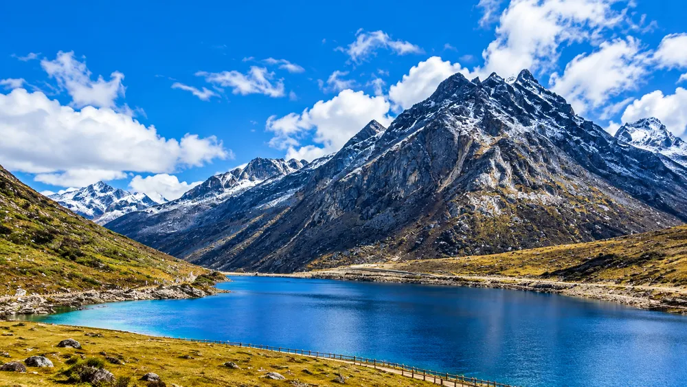
Sela Pass is a high mountain pass in western Arunachal Pradesh, and for decades it was the most demanding stretch on the road between the plains and Tawang. The old road climbs to roughly 13,700 feet, crosses a cold, open ridge and then drops toward the Tawang valley. Travellers have long treated it as a highlight of the journey as well as an obstacle, because the landscape changes so sharply once you leave the forests of Dirang behind.
The pass looks different today. A road tunnel opened in 2024 now carries most traffic under the ridge, so the old route over the top is mainly a choice for visitors who want to see the pass and the lake beside it. This guide explains where Sela Pass is, how the tunnel changes the journey, what the weather can do, and how to fit a stop into a Tawang trip safely. Road status, snow and permits change often, so we mark where you should check locally before you leave.
Where is Sela Pass?
Sela Pass lies on the border between West Kameng and Tawang districts in Arunachal Pradesh. It sits on National Highway 13, the main road linking Assam with Tawang, and it is often described as the gateway to Tawang. Once you cross it you are in Tawang district, which shares borders with Bhutan and China.
Sources give slightly different distances, but Sela is roughly 60 km from Dirang, about 100 km from Bomdila and around 75 to 80 km from Tawang. Treat these as approximate and ask your driver for current figures.
That position makes it the natural halfway marker of the Tawang road. Most travellers reach Dirang or Bomdila the night before, cross Sela the next morning and arrive in Tawang later that day.
Why is Sela Pass famous?
The landscape is the main reason. Above the tree line the road runs through open, treeless terrain with snow-streaked slopes, scattered boulders and long views across ridgelines.
Sela Lake is the second draw. It sits just below the pass at around 4,100 metres and is a small glacial lake that stays frozen for much of the year, according to local sources. It is also sometimes called Paradise Lake. The lake is close to the old road, so you reach it if you go over the pass rather than through the tunnel.
There is a parking area near the pass, and reports mention a small cafeteria run for visitors and troops, though facilities can change, so do not rely on them.
The pass also matters historically. NH 13 was long the lifeline for Tawang and the army posts beyond it, and the war memorial at Jaswantgarh, on the Tawang side, tells the story of the 1962 conflict for those who want to understand the region's past.
Sela Pass altitude and weather
The commonly quoted height of Sela Pass is about 13,700 feet, or roughly 4,170 metres. Figures vary slightly between sources, so use "around 13,700 feet" rather than a precise number. The Sela Tunnel is lower than the pass, at roughly 13,000 feet by most accounts.
At this height the air holds less oxygen, the sun is strong and temperatures are cold for much of the year. Snow can fall in winter and may linger into spring, and the weather can change fast. A clear morning can turn to cloud, wind or snow within hours, and visibility can drop sharply. We do not give temperature figures here because they vary by season and by day, so check a current forecast before you go.
Altitude is the other consideration. Some people feel headaches, breathlessness, dizziness or nausea at this height, especially if they have come up quickly from the plains. Spending a night at Dirang or Bomdila before crossing helps your body adjust. Drink water, move slowly, avoid heavy exertion and do not stay longer than you need to at the top. If symptoms appear, go down and seek medical help. If you have a heart, lung or blood pressure condition, or you are pregnant, talk to a doctor before travelling.
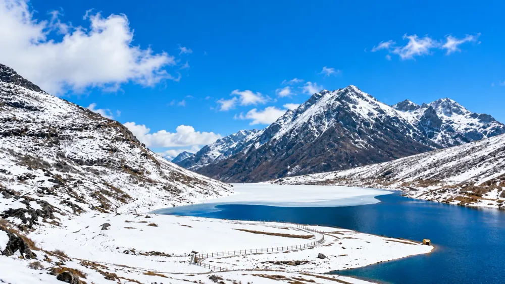
Sela Pass in winter
Winter is when the pass looks most dramatic and when it is hardest to travel. Snow may cover the road, the lake and the slopes, and the temperature can fall well below freezing. Snow is a fair reason to visit, but it is never guaranteed on a particular date, and a winter trip can still end up dry and cold.
Road conditions change the most in this season. Snow and ice can make the old road slippery or temporarily unsafe, and closures or delays can happen at short notice. The tunnel now gives a more reliable route toward Tawang, but that does not guarantee smooth travel on the roads leading to it, and conditions beyond the tunnel can still be affected by snow.
Dress for serious cold, with thermals, a windproof and waterproof jacket, insulated gloves and spare layers, and wear sunglasses against snow glare. Start early, build in buffer time and do not push on in poor visibility or on a road that officials or drivers say is unsafe.
Never walk on a frozen lake, however solid it looks. Ice conditions are unpredictable and people have died in accidents on frozen water in the region.
How to reach Sela Pass
Sela Pass is on the road from Assam to Tawang, so you reach it by road through the Arunachal foothills.
Most travellers start from Guwahati or Tezpur in Assam. From Guwahati the usual route runs through Assam to Bhalukpong, where you enter Arunachal Pradesh, and then climbs to Bomdila and Dirang. The journey is long, and most people break it with a night at Bomdila or Dirang rather than doing everything in one day. From Dirang, the road climbs to Sela and continues to Jang and Tawang.
The nearest large airport is Guwahati, and the nearest airports closer to the route, such as Tezpur, have limited services, so check flights before you rely on them. There are no trains into Arunachal, so the railhead is in Assam, usually Guwahati or a station near Tezpur. From there you continue by road, using a hired car, a shared vehicle or a bus.
Indian citizens who do not live in Arunachal Pradesh need an Inner Line Permit, and foreign visitors need the relevant permit.
Sela Pass and Sela Tunnel
Sela Pass is the historic high-altitude road over the ridge. The Sela Tunnel is a pair of tunnels on NH 13, built by the Border Roads Organisation and inaugurated on 9 March 2024. It runs below the pass, at around 13,000 feet, and lets traffic bypass the highest and most weather-exposed part of the road. Reports describe two tunnels: one of about 1 km, and a second of about 1.6 km with a twin-tube layout, one for traffic and one for emergency use. They are linked by a new road of around 12 km. Exact lengths differ slightly between sources.
The tunnel shortens the drive between Dirang and Tawang, with accounts giving a saving of about 10 km and somewhere between one and two hours of travel time. It is also designed to keep the route open in bad weather.
Current reports say the old road over the pass is still open when conditions allow, and that most local and army traffic uses the tunnel. Tourist vehicles that want to see the pass go over the top. That means the old road may receive less maintenance than before, so its condition can change. We cannot confirm today's status of either route, so ask your driver or the local authorities about the current arrangement, and expect that on some days the old road may be closed or restricted.
Ask your driver about going over the pass in good weather and use the tunnel when visibility is poor. Do not insist on the pass if the driver advises against it.
Best time to visit Sela Pass
Spring, roughly March to May, brings warmer days and melting snow at lower levels, though the pass itself can still hold snow early in the season. Skies are often clearer and roads more open than in midwinter, so it is a good time for many travellers.
Summer and the monsoon, roughly June to September, are the wettest months. Rain, fog and landslides can slow or block the road, and visibility at the pass can be poor. The hills are green and lush, but it is a harder time to travel, so allow extra days and stay flexible.
Autumn, roughly October to November, is often considered one of the best times. The air is dry, skies tend to be clear, and Sela Lake can look its most vivid. Nights are cold and snow is possible late in the season.
Winter, roughly December to February, is the coldest and the most likely time for snow. It suits travellers who want a winter landscape and are prepared for cold and possible delays. It is not the best choice for a first mountain trip.
What to carry
Pack for cold, sun and sudden changes. Warm layers matter most: thermals, a fleece or down jacket and a windproof outer shell. Bring insulated gloves, a hat and warm socks. Sunglasses are essential because the sun and any snow glare are strong at this height. Carry a rain and snow jacket or poncho, since weather can shift quickly.
Bring drinking water, sun protection, a torch and a few snacks, as food stops on the route are limited and may be closed. Keep any personal medication with you, plus a small first-aid kit, and ask your doctor about altitude if you have any health concerns.
Safety tips
Check the weather and road status before you leave each morning, and be ready to change plans. If your driver, local police, army personnel or the road authorities advise against going, listen to them.
Watch for altitude symptoms and do not ignore them. Do not rush up from the plains in one day, and do not stay on top longer than needed. If someone in your group feels unwell, descend and get medical help.
Get a vehicle ready and use a driver who knows the route. A vehicle with good brakes, tyres and a proper fuel margin matters on steep, cold roads. Drive slowly on ice, avoid night driving on the high sections and leave space between vehicles.
Respect restrictions. The route passes military areas, and some places have photography limits or entry rules. Follow signs and instructions, and never photograph installations where it is prohibited. Keep away from cliff edges and frozen water, and do not leave litter.
Sela Pass in a Tawang itinerary
Sela fits naturally into the outbound or return leg of a Tawang trip. A common plan is to spend the first night at Bomdila or Dirang, cross Sela the next morning and reach Tawang by afternoon or evening.
For a five to seven day trip, allow one day for the drive from Guwahati to Bomdila or Dirang, one day for the crossing to Tawang, one or two days to see Tawang, and a return journey with an overnight stop. If you are worried about time or weather, use the tunnel on one leg and the pass on the other, as many travellers do, depending on conditions.
A short stop at the pass and lake, perhaps 30 to 45 minutes, is usually enough. Do not linger if you feel unwell or the weather is turning.
Frequently asked questions
What is the altitude of Sela Pass?
Sela Pass is commonly given as about 13,700 feet, or roughly 4,170 metres. Figures vary slightly between sources.
Where is Sela Pass located?
It lies on the border of West Kameng and Tawang districts in Arunachal Pradesh, on National Highway 13 between Dirang and Tawang.
Will I see snow at Sela Pass?
Snow is possible, especially in winter and early spring, but it is never guaranteed on any given day. Check current conditions before you travel.
What is the best time to visit Sela Pass?
Autumn and spring are often the most comfortable, with clearer skies and easier roads. Winter is the most likely time for snow but also the hardest for travel.
Is Sela Lake worth visiting?
Sela Lake sits just below the pass and is a popular stop. It can be frozen for much of the year, and it looks different in each season. It is on the old road, not on the tunnel route.
What is the Sela Tunnel?
It is a pair of tunnels on NH 13 that bypass the pass, inaugurated on 9 March 2024. They shorten the route and help keep it open in bad weather.
Do I still pass through Sela Pass if I use the tunnel?
No. The tunnel goes under the ridge and bypasses the pass and the lake. To see them you need to take the old road when it is open.
Is the old road over Sela Pass open?
Current reports say it is usually open when conditions allow, but this can change. Ask your driver or local authorities about the current status.
How do I reach Sela Pass from Guwahati?
Travel by road through Bhalukpong, Bomdila and Dirang. Most travellers break the journey with a night in Bomdila or Dirang.
How far is Sela Pass from Tawang?
Sources give roughly 75 to 80 km, so plan for several hours on mountain roads, and ask your driver for current timings.
Do I need a permit to travel to Sela Pass?
Indian citizens who do not live in Arunachal need an Inner Line Permit, and foreign visitors need the relevant permit. Check current requirements before you travel.
Can I get altitude sickness at Sela Pass?
It is possible, particularly if you ascend quickly. Spend a night at Dirang or Bomdila first, drink water, move slowly and descend if you feel unwell.
Is Sela Pass safe to visit in winter?
It can be, with preparation, but snow and ice bring real risks. Check road status, dress for serious cold, follow local advice and allow extra time.