Walong sits at the far eastern edge of Arunachal Pradesh, in Anjaw district, on the banks of the Lohit River not far from the international border. It is a small administrative town with a modest army presence, a war memorial and a road that takes much longer to drive than the map suggests. People make the trip for the landscape, for the history of the 1962 conflict, and for the early-morning trek to the Dong viewpoint above the valley.
This guide covers where Walong is, what to see around it, how to reach it, when to go and how to plan a realistic stay. It treats the border setting as a fact of geography, not a selling point, and it flags anything that changes often or depends on local permissions so you can confirm before you travel.
Where Is Walong in Arunachal Pradesh?
Walong is the headquarters of Walong circle in Anjaw district, in the far east of Arunachal Pradesh. District information places it at around 1,094 metres above sea level and about 58 km from Hawai, the district headquarters. By road it is roughly 200 km from Tezu in Lohit district, though the journey is far slower than that number implies.
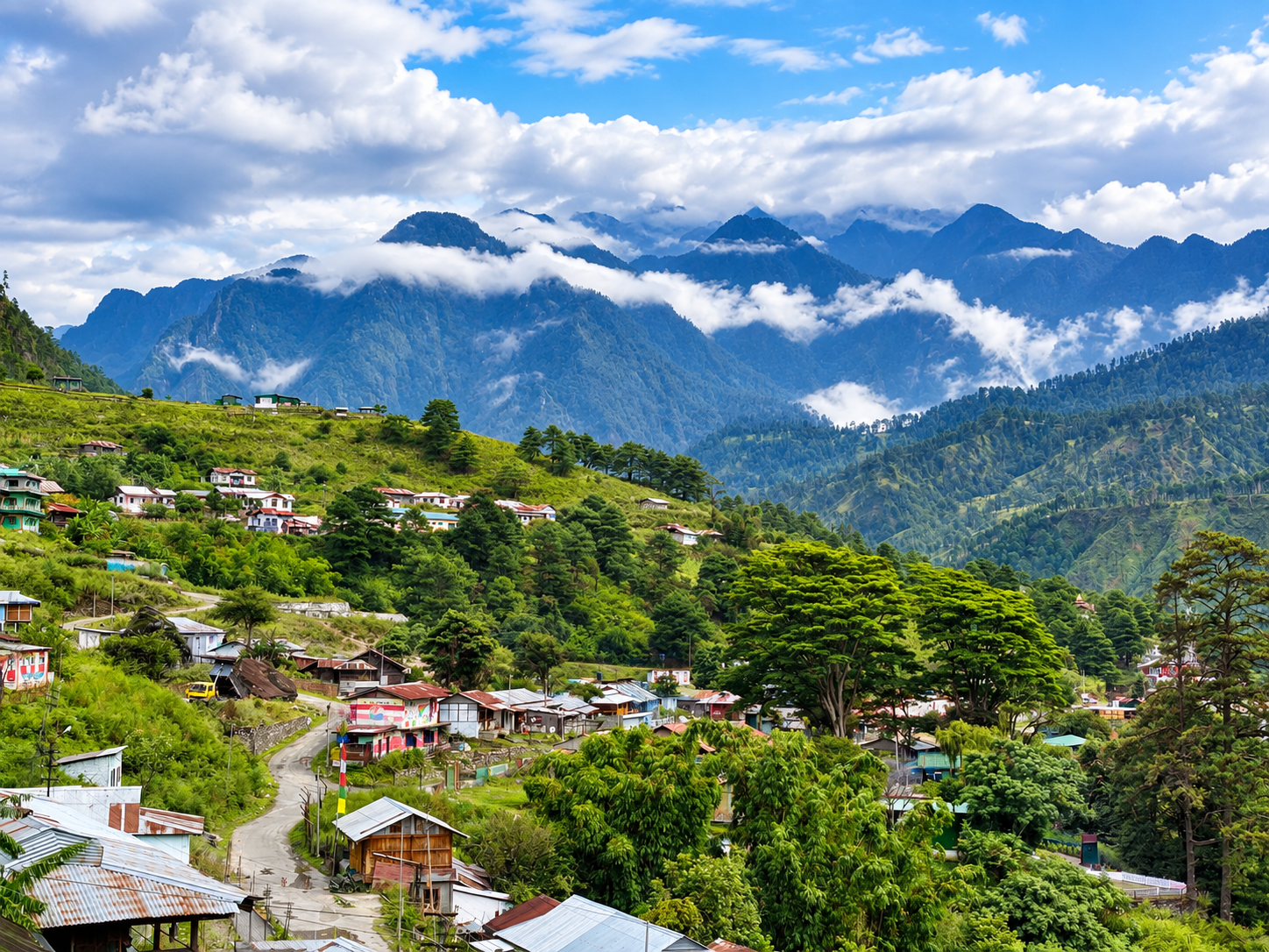
The setting is a river valley with steep forested hills on either side, cut by the Lohit as it flows down from the north. The name is said to come from the Mishmi language and to mean a place of bamboo groves. The population is largely Mishmi and Meyor.
Walong matters geographically because of where it sits: close to the trijunction area where India, China and Myanmar meet, in one of the most remote parts of the state. That location explains both its strategic history and the restrictions that apply to parts of the area today.
Why Visit Walong?
Walong is not a place for a quick stop, and it suits a particular kind of traveller.
Remote mountain landscapes. Long river valleys, forested slopes and a lack of large settlements give the area a spacious, quiet feel.
Frontier setting. The region is close to the border, and that shapes daily life, transport and access. It is worth understanding this without turning it into a spectacle.
Sunrise experiences. The Dong viewpoint is the main draw for many visitors, and the early climb is part of the experience.
River valleys. The Lohit and its tributaries define the scenery, and roads follow the river for long stretches.
Village life. Meyor and Mishmi communities live in the surrounding valleys, and respectful visits give context to the landscape.
Long road journeys. For many travellers, the drive through eastern Arunachal is as much of the trip as the destination.
Historical significance. The Battle of Walong in 1962 is central to the town's identity, and the memorial is the best-known site.
Places to Visit in and Around Walong
The number of reliably documented attractions is small, so this list is short by design.
Walong War Memorial
A memorial to Indian soldiers killed in the 1962 conflict, located just north of the town near the airstrip. It is the best-known landmark, and many visitors come here first. Allow about an hour. One regional guide lists visiting hours of 9 am to 4 pm, but timings can change and access depends on army arrangements, so confirm locally. Visit quietly, and treat it as a place of remembrance.
Dong and the Millennium Point
A viewpoint on a plateau above the Lohit, reached by an early-morning climb, and the focus of the sunrise trip. It is covered in detail in its own section below.
Namti Valley (Namti Maidan)
District tourism information describes Namti Valley, near Walong, as the place where fighting took place in 1962. Access can depend on army permissions and local conditions, so ask before you plan it. It is best approached as a historical site rather than a scenic stop.
Helmet Top
Regional guides mention a war memorabilia site at Helmet Top, around 18 km uphill from Walong at about 2,250 metres, inside an army camp. Because it is inside a military area, access is not guaranteed. Do not plan around it without confirming permission in advance.
Tilam Hot Spring
A small hot spring by the Lohit near the guest house area is mentioned in several accounts. It is a short, low-key stop and a common starting point for the Dong trek. Facilities are basic.
Kibithoo
A settlement roughly 23 km from Walong along the west bank of the Lohit, described in travel accounts as a scenic drive. Access beyond it is restricted for civilians, as noted below.
Dong Valley and the First Sunrise Experience
Dong is a plateau above the Lohit near Walong, and the climb to its viewpoint is one of the most talked-about parts of a trip here. Accounts describe leaving in the dark, around 3 or 4 am, crossing the river by a suspension bridge and climbing for roughly 90 minutes. Many travellers go with an approved local guide, and the guide's local knowledge of the trail and weather is valuable.
Context. Dong has been widely promoted as the place where the first rays of the sun fall on India, a description that became popular around the year 2000. Treat that as a popular label instead of an official title. Which place counts as first depends on how the location is defined, on the season and on the viewing point, so the claim is best worded with care. What is undisputed is that the eastern location means early sunrise and long, low light across the valley.
Whether Dong is inhabited. Accounts differ. Some describe Dong as a village, while an earlier account says the few households there moved to a nearby village because of water shortage and that there is no motorable road to the plateau. Ask locally what the situation is now.
Doing it responsibly. The climb is steep, cold and in the dark, so go with a guide and carry warm layers, a torch and water. Do not expect camping to be possible or permitted. Sunrise depends on cloud cover, and some travellers have found the view obscured, so treat a clear sunrise as a possibility, not a promise. Keep noise down near homes and leave no litter.
History and the 1962 Context
Walong was the scene of fighting during the Sino-Indian War of October and November 1962. Indian troops, including units of the 11th Infantry Brigade, fought Chinese forces in the Walong sector, which included areas around Kibithoo and the Namti plain. Accounts describe Indian forces as heavily outnumbered and operating in very difficult terrain. Indian forces were pushed back in the fighting, and the territory was later regained after Chinese forces withdrew. Sources give varying casualty figures, so it is better to consult specialist histories than to rely on a single number.
The memorial by the airstrip honours the Indian dead, and its inscription references the Namti plain and the Lohit river. Commemorative events have taken place in recent years, including army-organised events in November.
Treat this history with the seriousness it deserves. Visit the memorial respectfully, keep conversation quiet, and avoid treating the site as a photo stop. Some sites in and around Walong are inside military areas, and access rules apply.
Local Culture and Communities
The Mishmi and Meyor communities are the main populations in and around Walong. They are distinct communities with their own languages, dress and customs.
Village life. Farming, foraging and small-scale trade remain important, alongside government and army-related work in the town.
Beliefs. One travel account notes that Meyors are predominantly animist, with some influence from Mahayana Buddhism, and that some villages have gompas. Practices vary between villages, so listen to local explanations rather than assuming.
Food. Meals are simple, built around rice, greens, local vegetables and, in many households, fish or meat. Choices in town are limited, and the best food experiences come through hosts.
Traditions. Do not assume that any ceremony or festival will be available to visitors. If you hope to see a community event, ask well in advance through a local contact and follow their guidance.
Respect. Ask before photographing people or homes, dress modestly in villages, accept hospitality graciously and avoid treating traditional dress or customs as props.
Things to Do in Walong
- Visit the war memorial in quiet respect
- Take the pre-dawn trek to Dong with a local guide, weather permitting
- Drive the river road toward Kibithoo, within the limits of permitted areas
- Walk around the town and nearby villages, with hosts where possible
- Photograph the valley in early and late light
- Spend time at the Tilam hot spring
- Try angling on the Lohit if a local host arranges it
- Ask about nature observation in the surrounding forest, without expecting specific wildlife
Do not photograph military installations or personnel, and follow instructions from security staff.
How to Reach Walong
By air. District information lists Mohanbari airport at Dibrugarh in Assam as the gateway. Confirm current flights before booking.
By rail. New Tinsukia Junction is listed as the railhead.
By road. The route runs from Tinsukia through Tezu and Hawai to Walong. Some travellers break the journey at Hayuliang. An army motorcycle expedition covering the route from Roing through Tezu and Hayuliang to Walong took three days to travel around 550 km, which gives a sense of the scale.
Why it takes so long. Tezu to Walong is about 200 km on paper, but one traveller describes it as a full day because of rough sections. A government-published itinerary suggests 10 to 12 hours from Dibrugarh or Tezpur, but times vary widely with weather, repairs and landslides. Treat any estimate as a minimum and plan a buffer.
Local transport. Shared vehicles and private hire are used in the region. This guide does not quote fares or schedules, since they change often. Confirm locally and expect fewer services than in larger towns.
Best Time to Visit Walong
Winter (November to February). Cold, especially on the pre-dawn Dong trek, with clearer skies more likely and roads generally more reliable. A popular choice for sunrise travel, though visibility is never guaranteed.
Spring (March to April). Milder weather and greener valleys, with increasing rain later in the season.
Summer and monsoon (May to September). Heavy rain, landslides and river flooding are realistic risks on this route, and cloud often obscures views. This is the hardest season to travel in.
Autumn (October to early November). Often a good window as rains ease, though roads may still be recovering.
For sunrise, cold, clear mornings are generally better than wet or cloudy ones, but conditions change quickly in mountain country. Check the forecast and ask locally the day before.
How Many Days Do You Need?
3 days. Enough for the journey in, one day at Walong with the memorial and a sunrise attempt, and the journey out, if you start from Tezu or a nearby overnight stop. It is tight, and any road delay eats into it.
4 days. A more comfortable length that allows a rest day after the long drive, a second chance at the sunrise if the first is clouded, and time for a village visit.
Add extra days for the journey from Assam, since the road from Tinsukia to Walong itself takes more than a day.
Where to Stay in Walong
Accommodation in Walong is limited and basic. Options generally include government or private guesthouses, inspection bungalow-style lodging, and a small number of homestays. Availability is limited, and rooms may fill up quickly around holidays and commemorative events.
Expect simple rooms, limited menus and possible power or water interruptions. This guide does not name properties or quote prices, since they change. Book ahead through a local operator or contact accommodation directly, and confirm facilities before you go.
Food and Supplies
Facilities in remote areas are limited. Meals are usually simple, and shops stock basics rather than a wide range.
Carry snacks, water, any medicines you need and spare batteries or a power bank. If you have dietary requirements or allergies, tell your host early. Stock up on fuel and cash in larger towns before heading up, because the supply of both thins out along the way.
Permits and Travel Documents
Indian citizens who are not residents of Arunachal Pradesh generally need an Inner Line Permit (ILP) to enter the state. Foreign nationals require a Protected Area Permit, usually arranged through a registered tour operator.
Walong is a frontier area, and rules for specific locations can differ from the general ILP. One regional guide notes that civilians are not permitted beyond Kaho village, roughly 26 km north of Walong. Access to military sites and some viewpoints can also depend on army permission. Confirm current requirements with the official ILP portal, the district administration or a registered local operator before you travel, and carry printed and digital copies of your documents and valid photo ID.
Walong Travel Tips
- Cash. Carry enough, since ATMs and digital payments are unreliable in remote areas.
- Network. Mobile coverage is patchy, so download maps and documents in advance.
- Fuel. Fill up in larger towns, because fuel is hard to find further along.
- Clothing. Warm layers, rain protection and sturdy footwear are important, especially for the pre-dawn climb.
- Weather. Conditions change quickly and can affect both roads and views.
- Road conditions. Check before each leg, and add buffer time to your plan.
- Emergency planning. Tell someone your route, carry basic medicines and know that medical facilities are limited.
- Photography. Follow signage and instructions, and do not photograph military installations or personnel.
- Security-sensitive areas. Respect restrictions and checkpoints, and do not try to go beyond permitted areas.
Sample Walong Itinerary
Day 1: Tezu to Walong. Leave early for the long drive along the Lohit valley, with stops as conditions allow. Check in and rest.
Day 2: Memorial and sunrise preparation. Visit the war memorial in the morning, walk around the town and the hot spring in the afternoon, and prepare for an early start.
Day 3: Dong sunrise and return. Climb to Dong before dawn with your guide. After breakfast, begin the drive back toward Hayuliang or Tezu.
Optional Day 4. Use a fourth day as a buffer, for a second sunrise attempt if the first is clouded, or for a village visit.
Adjust to conditions, and do not plan tight connections after the drive out.
Frequently Asked Questions
Where is Walong? Walong is in Anjaw district in the far east of Arunachal Pradesh, on the Lohit River near the international border.
How far is Walong from Tezu? About 200 km by road, but the journey is slow and often takes most of a day.
Is Dong the first sunrise in India? Dong is widely marketed as the place where the first rays of the sun fall on India, but the claim depends on how the location is defined. Treat it as a popular label.
How do you reach Walong? By road via Tinsukia, Tezu and Hawai. The nearest airport is Dibrugarh in Assam, and the nearest railhead is New Tinsukia.
Do you need a permit for Walong? Non-resident Indian citizens generally need an Inner Line Permit, and foreign nationals need a Protected Area Permit. Additional restrictions can apply near the border, so confirm current rules.
What is the best time to visit Walong? Late autumn through early spring is generally more comfortable. The monsoon brings rain, landslides and cloud.
How many days do you need? Three to four days from Tezu, plus additional time for the journey from Assam.
What happened at Walong in 1962? It was the site of fighting during the Sino-Indian War in October and November 1962, and a memorial near the airstrip honours the Indian dead.
Can tourists go to Kibithoo or the border? Access depends on current rules and permissions. One guide notes that civilians cannot go beyond Kaho village, so confirm before planning.
Conclusion
Walong Arunachal Pradesh rewards patience more than any other quality. The road is long, the accommodation is basic and the views depend on weather, but the memorial, the river valley and the early climb to Dong give the trip real weight. Go with realistic expectations, confirm permits and access rules before you leave, and treat the history and the communities with respect. Handled that way, a few days in Walong can be one of the more memorable parts of an eastern Arunachal journey.